Deep Learning in Agriculture
Deep Learning in Agriculture
Precision Agriculture (PA) is comprised of near and remote sensing techniques using IoT sensors, Drones, UAVs and Satellites, which help to monitor crop states at multiple growth levels. PA involves the acquisition and processing of a large amount of data related to crop health. Multiple parameters are involved in plants health, including water level, temperature and others. PA enables a farmer to know precisely what parameters are needed for a healthy crop, where these parameters are needed and in what amount at a particular instance of time. This requires collecting massive information from different sources and different parts of the field such as soil nutrients, the presence of pests and weeds, chlorophyll content in plants and some weather conditions. All collected information needs to be analysed to produce agronomic recommendations. For instance, given the developmental stage of plants, their level of greenness (chlorophyll content) reveals the nutrients needed. This information is combined with the characteristics of the soil where the plant is located along with weather forecast. All collected information is further used to determine how much of a certain fertilizer should be applied to that plant on the next day. The delivery of agronomic information on the right time to the farmer and ensuring that he/she applies these recommendations are key to enhancing the yields.
The foremost driver of PA is a WSN (Wireless Sensor Network), which is a network of multiple wireless nodes connected together to monitor the physical parameters of the environment. Each wireless node is comprised of a radio transceiver, a micro-controller, sensor, an antenna, along with other circuitry that enables it to communicate with some gateway to transmit information collected by the sensor. Sensors measure the physical parameters and send the collected information to the controller, which further transmits this information to the cloud or a portable device. The agriculture sector has multiple requirements comprised of soil statistics, crops’ nature, weather conditions, fertilizer types and water requirements. Crops have diverse requirements depending on different crops on the same land and the same plant on different lands with different weather conditions. Multiple applications of wireless sensor networks are being utilized today in the agriculture sector to monitor the varying behaviour of these crop parameters. Some very common applications are smart irrigation, smart fertilization, smart pest control and greenhouse monitoring.
Remote sensing has been widely used in PA to monitor crops’ health for the last two decades. Remote sensing is a phenomenon in which physical conditions of the Earth are observed remotely by calculating the emitted and reflected radiation from some distance. There are special cameras that are used to capture images for further analysis to find the characteristics of a specific area. Multiple platforms are used to mount these cameras that capture images of the objects. Space-borne platforms for remote sensing are considered to be the most stable platforms among all others.
The advantages of satellite-based remote sensing include high spatial resolution, which makes it promising to extract extensive time-series data. The images obtained by satellite platforms cover a large area and are stable without noise, which is normally induced due to interference while image capturing. However, the main problem with satellite-based platforms is their high cost in the case of high spatial resolution images. The second problem is their strictly fixed time schedule, so data cannot be collected at critical timings. The re-visitation times vary from twice in one day to 16 days, depending on the orbit of the satellite. The other big problem is that satellite platforms are highly sensitive to weather conditions, so if the weather is cloudy, the captured image will have less detailed information.
The table below shows the main types of satellites with their specifications
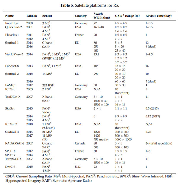
Some satellite data are freely available, while others provide a commercial solution. The commercial solutions such as Planet Labs provide images with a high resolution and a revisit time of one day. Worldview, Landsat-8 and Sentinel are frequently-used satellite platforms used to obtain hyperspectral imagery. Planet Labs provides a small revisit time, but it is a commercial solution. In contrast to Planet Labs, Landsat-8 and Sentinel provide free solutions. Landsat-8 was launched in 2013 by the USA. Landsat-8 provides a revisit period of 16 days with PAN and 11-MS imagery sensors. Though revisit time of Landsat-8 is much higher compared to Planet Labs, but it provides images with 11 different multi-spectral bands.
Sentinel is another broadly-used satellite launched by the EU. It currently has three missions, i.e., Sentinel-1, Sentinel-2 and Sentinel-3. These missions provide images with 21 MS bands with revisit times of 5–10 days depending on which Sentinel mission is used. However, Sentinel-2 is a commonly-used platform in precision agriculture as it provides data freely at a 10-m spatial resolution and covers a swath width of 290 km. By combining Sentinel-2A and Sentinel-2B, the revisit time is further reduced to five days, which helps in change detection.
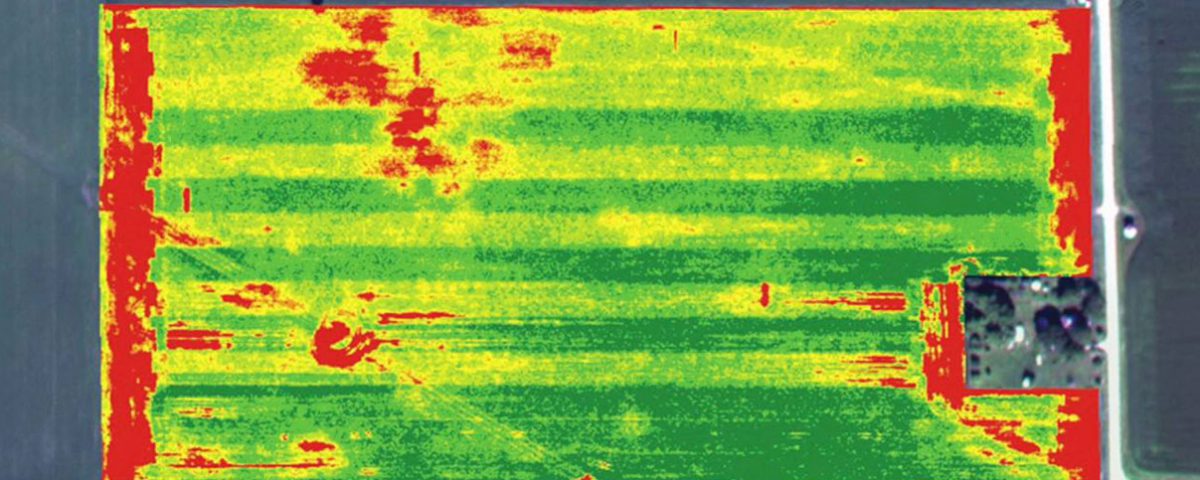
Using multi-spectral images from the remote sensors described above, a series of Vegetation Indices (VIs) can be computed. Vegetation Indices (VIs) obtained from remote sensing-based canopies are effective algorithms for quantitative and qualitative evaluations of vigour, vegetation cover and growth dynamics, among other applications.
To precisely monitor the crop health, both IoT-based techniques and remote sensing techniques should be used together to provide more reliable and accurate information about the crop.